Tuesday, September 29, 2009
Pylos Niokastro
In 1573, two years after the defeat of the Ottoman fleet at the battle of Naupaktos (Lepanto), the Turks built the fortress of Pylos, in order to control the southern entrance to the bay of Navarino, the largest natural harbour in the Peloponnese. The new fortress was called Niokastro (New Castle), to distinguish it from the Old Castle, the Frankish castle on the peninsula of Koryphasion, which had controlled the opposite, northern entrance to the bay up to that time.
Pylos is famous for the naval battle fought on 20 October 1827, during the Greek War of Independence, in the bay of Navarino. An Ottoman and Egyptian armada was destroyed by a combined British, French and Russian naval force. The Battle of Navarino was the last major naval battle in history to be fought entirely with sailing ships.
This is a view from the top of the Niokastro wall. The island in the distance is called Sfaktiria.
Thursday, September 24, 2009
Ice-cream van
I like this photo as it shows summer in the city - no parks, no beaches, just sleeveless dresses, bare legs and ice-cream purchased from the ice-cream van.
It's been a beautiful sunny day today, so I'm in a summer mood. Here's hoping that the blue skies and warm sun put in an appearance tomorrow too.
Tuesday, September 22, 2009
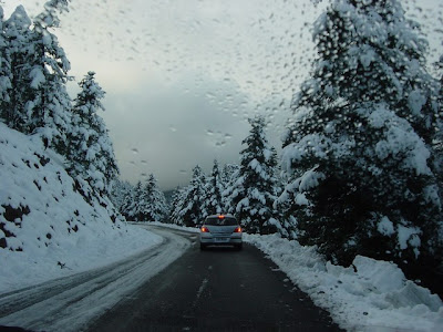
Snowy mountain road
It turns out I don't go to the mountains all that often, as I have too few photos of trees and mountain tops. This one is probably the best one in my collection, taken through the car windscreen as we were leaving the Mainalo Ski Resort on New Year's day five years ago. At this point, we're at 1,500 m. above sea level.
Monday, September 21, 2009
Arcadian landscape
This is a typical Arcadian view. High mountains and tiny plains make up approximately 90% of the land in Arcadia, in central Peloponnese.
The colour squares arranged in a line are beehive boxes. Beekeeping is very popular in Arcadia because of the fir blossom pollen which gives a uniquely aromatic honey.
Friday, September 18, 2009
Panigiri at Levidi
During the summer months, there are a number of religious festivals taking place in villages all over Greece. These consist of special church services during the day, followed by merriment in the evening. The merriment bit includes music, dancing, eating and shopping at the open air markets that are set up. The Greek name for this type of festival is "panigiri".
I took this photo at a panigiri in Levidi, in rural Arcadia. This is the village's main square, where tables and chairs were set out for the revellers. On the left of the picture, behind the fountain, you can see there is music and dancing going on.
It was a quarter past midnight when I snapped this, and the celebration was still going strong when we left at 1:30 AM.
Tuesday, September 15, 2009
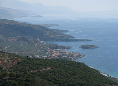
Approaching Kardamili
This is the seaside village of Kardamili in the Messinian Mani. The village in the distance is Stoupa. You have to drive down a winding mountain road to get to Kardamili and Stoupa, but the views more than make up for it.
It was very hazy when we were there and the light was strange. I'd love to go back and take the same photo on a clear day.
Sunday, September 13, 2009
Butterfly and flower
This is a butterfly I photographed last month in Greece. Having spent ages looking through various butterfly websites, I think this is a High Brown Fritillary, which is quite rare in the UK.
Or it could be a Dark Green Fritillary. Or a Common Leopard (according to hubby).
Anyway, I don't know what it is, but it sure was quite pretty and I'm delighted it stood still long enough for me to snap this photo.
Saturday, September 12, 2009
A church on Siros
I took this picture from the boat and had to zoom right in, so it's not very sharp. I like it because it illustrates the crowded architecture of Ermoupoli. I love the way the church is poking through the houses.
Thursday, September 10, 2009
Santorini at dusk
Santorini is a small, circular archipelago of volcanic islands located in the southern Aegean Sea, about 200 km SE of the mainland. They are essentially what remains of an enormous volcanic explosion which destroyed what was formerly a single island, and lead to the creation of the current geological caldera.
Wednesday, September 9, 2009
Corinth Canal
This photo is really special to me. I've been to the Corinth Canal several times, but this is the first time I've managed to photograph a ship sailing through it.
The Corinth Canal connects the Gulf of Corinth with the Saronic Gulf in the Aegean Sea. It cuts through the narrow Isthmus of Corinth and separates the Peloponnese from the Greek mainland, effectively making the Peloponnese the largest Greek island.
The Canal was built between 1881-1893, it's 6.3 kilometres long and 24.6 metres wide at sea level. Its construction was planned, organised and supervised by the Hungarian architects István Türr and Béla Gerster. The Canal has been open to traffic since October 1893 and has reduced the distance between the ports of the Aegean and the Adriatic Sea by 131 nautical miles (243 kilometres).
Tuesday, September 8, 2009
Early morning Mykonos
Subscribe to:
Posts (Atom)